
Epsilon Systems’ team members have more than 20 years of experience in environmental site investigation, regulatory compliance, and environmental management activities on private, municipal, tribal, and federal lands.
Epsilon Systems provides expertise in water quality sampling and analysis, groundwater modeling, vulnerability assessments, and watershed studies. Epsilon Systems is also proficient in facility compliance analysis, including experience with solid waste management plans, Emergency Planning and Community Right-To-Know Act (EPCRA) documentation, pollution prevention programs, spill contingency plans, and risk management services.
Some of the areas in which Epsilon Systems provides support for environmental programs include:
- Preliminary assessment site investigation/Phase I, II, and III site assessments
- Environmental management systems development and implementation (for ISO 14001)
- Pollution prevention program planning
- Environmental database design, development, and management
- Technical work plans, procedures, and protocols
- Environmental compliance and permitting required by the Resource Conservation and Recovery Act (RCRA), Clean Air Act, Clean Water Act (CWA), National Pollutant Discharge Elimination System, National Emission Standards for Hazardous Air Pollutants, and other federal, state or local regulations
- Worker health and safety programs, including Occupational Safety and Health Administration (OSHA) requirements
- Army Corps of Engineers 404 permitting
Capabilities
Environmental Management Services
- Environmental Management Systems (EMS) development and implementation (for ISO14001)
- Facility environmental audits and inspections for loss control and quality assurance/quality control purposes
- Pollution Prevention (P2) program development
- Environmental database management
- Technical work plans, procedures, and protocols
- Environmental compliance and permitting
- Program development, review, and implementation
- Worker health and safety programs, including OSHA requirements
- Permitting and compliance:
- National Environmental Policy Act (NEPA)
- Clean Water Act
- CAL Environmental Quality Act (CEQA)
- Air
- Natural resource management
- Endangered species surveys
- Geographic Information Systems (GIS)
- Military Compatibility Analysis Tool (MCAT)
- Spatial data analysis, data management and map production
- High end graphics design
- Cultural Resources Surveys (CRM)
- Section 110 and 106 surveys and compliance
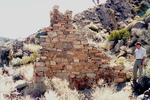
- Historic and prehistoric archaeology
- Historic building renovation and protection
- Historic American Building Survey/Historic American Engineering Record (HABS/HAER)
Cultural Resources Management
Epsilon Systems’ cultural resources management staff consists of Secretary of the Interior (SOI)–qualified archaeologists, historians, and architectural historians with extensive experience throughout California and New Mexico. Our professionals possess the capabilities to review, assess, and facilitate comprehensive cultural resources management programs, including the following:
- Prehistoric and historic surveys, testing, and data recovery
- Section 106 and 110 consultations
- Mitigation planning and monitoring
- Curation and archival management
- Ethnographic studies
- Archival research
- Historic American Buildings Survey (HABS) and Historical American Engineering Record (HAER) documentation
- National Environmental Policy Act (NEPA) and CAL Environmental Quality Act
- (CEQA) documentation
- Historical architecture

Cultural Resources Management
Comprehensive Environmental Services
Environmental Compliance Services
Natural Resources Management
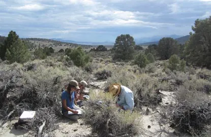
Comprehensive natural resources management includes planning and support services, such as surveying, assessing, and managing species of concern and their habitats. Species of concern are often drivers for many of the biological resource projects Epsilon Systems currently handles. These projects frequently include Epsilon Systems' personnel are currently providing natural resource management services in the following areas:
- Sensitive plant and wildlife surveys
- Biological baseline studies
- Endangered Species Act support (U.S. Fish and Wildlife Service Section 7 coordination)
- Mitigation planning and monitoring (best management practices)
- Integrated Natural Resource Management Plans
- National Environmental Policy Act (NEPA) documentation
- Environmental impact assessments, including CEQA/NEPA documentation
- Surface and groundwater quality investigations
- Watershed studies

Natural Resources Management
Comprehensive Environmental Services
Environmental Compliance Services
Environmental and Range Support Services
Epsilon Systems Environmental Compliance team supports:
- Naval Air Warfare Center Weapons Division (NAWCWD) in China Lake, CA
- Nearly one million acres of Navy-owned lands within the remote Mojave Desert
- 36,000-square-mile Sea Range at Point Mugu, CA, including San Nicolas, and portions of Santa Cruz and San Miguel Islands
- Naval Air Station Patuxent River Complex, MD
- 13,800 acres of facilities
- White Sands Missile Range
- NEPA documentation
- Natural and cultural resources
Support includes environmental management, natural and cultural resources preservation and geographical information systems such as the Mission Capability Analysis Tool (MCAT). The un-encroached NAWCWD air and land ranges at China Lake provide unmatched geographic conditions in which to develop and test weapon systems and explore tactics for desert and mountain environments. NAWCWD provides efficient deployment of new weapon systems through its collocated laboratories, ranges, and weapons test squadrons. The sites support fleet training and tactics development, including major exercises on the Land Range, Superior Valley Tactical Training Range and Electronic Combat Range.

Remedial Investigation and Hazardous Waste Management Services
- CERCLA Section 106 and 107 investigations with multiple PRPs
- RCRA Facility Investigations (RFI) of sites with multiple solid waste management units
- Hazardous waste management compliance assistance
- Integration of laboratory analytical data with GIS and AutoCAD presentations