Epsilon C5I develops products to support numerous signal intelligence and cryptologic programs.
Technologies include signal acquisition and analysis; intelligence systems simulation and stimulation; emitter identification; radio fingerprinting and tracking; and Multi-INT Fusion.
Software Products
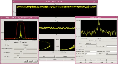
MARS
MARS is a portable and integrated suite of digital signal processing (DSP) software tools designed for signal recognition and classification, radio identification, signal generation, transformation, and analysis. It processes live radio frequency (RF) signals, stored signals, and streaming data samples from client applications.
MARS operates through a set of background "daemon" processes, supported by network-enabled application programming interfaces (APIs) and intuitive graphical user interfaces (GUIs). Hardware agnostic, MARS runs in single or distributed computing environments, supporting various operating systems, including Solaris/SPARC, Linux/x86 (32- and 64-bit), and Windows/x86 (32- and 64-bit).

Stallion
Stallion is a web-based event generation and simulation/stimulation system for training multiple operational and tactical C4I Systems.
Stallion:
- Feeds the tactical picture
- Drives simulators for the RF environment
- Includes import/export scenarios for sharing between commands
- Uses virtual machine deployment and web-based user interfaces
Stallion can be expanded to support training activities beyond those related to tactical cryptologic systems. As a generic web-based event generation and simulation tool, Stallion may support any number of event-driven scenarios, such as simulations to train emergency first responders.
Multi-Dimensional Plotter (MDP)
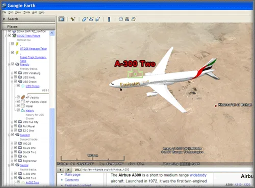
Multi-Dimensional Plotter (MDP) is an advanced, web-based, SOA server that rapidly produces KML, GeoRSS feeds, and 3D modeling data from any information source.
It displays the common operational track picture, 3D models of specified platforms for COMBAT ID, and shows fusion engine augmentation, amplification, and highlighted alerting. MDP is compatible with Open Layers, World Wind, and Google Earth client/plug-in.
Multi-INT Fusion
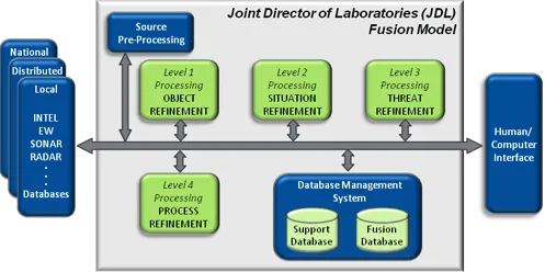
Epsilon C5I focuses its Multi-INT Fusion research to develop fusion services across distributed networks that can provide tracks, trends, behaviors, and highlight anomalies. Epsilon C5I uses a mix of theory and best practices in modern data trends that afford fusion of high volumes of data. These include: ontology mapping, Bayesian forecasting, Dempster-Shafer theory, multiple hypothesis theory, n-gram extraction, probabilistic latent semantic analysis (PLSA), and frequency histograms.
Specifically, Epsilon C5I develops:
- Algorithms that fuse unstructured and structured data to develop Objects (Level 1 Fusion), identify situations (Level 2 Fusion), and threats (Level 3 Fusion);
- Algorithms that overlay geopositional multi-INT reports directly into Full Motion Video;
- Analytic services for near real-time and historical event comparison; and
- Analytic services including alerting, change detection, and threat identification that enable users to identify and analyze networks.
Automatic RF Measurement Module (ARMM)
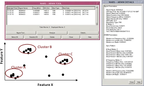
The Automatic Radio Frequency (RF) Measurement Module (ARMM) is an advanced suite of digital signal processing (DSP) algorithms designed to extract and report key features from communication signals. These measured features enable the association of similar emitters and differentiation of seemingly identical ones. ARMM also supports Specific Emitter Identification (SEI) and Specific Emitter Verification (SEV) by matching extracted features to known or reference values.
ARMM is a software-only solution capable of operating autonomously as background "daemon" processes or interactively via user-friendly graphical user interfaces (GUIs). It is highly scalable, running on a single general-purpose computer or within a distributed, heterogeneous, networked computing environment to meet varying throughput demands. ARMM is supported by network-enabled application programming interfaces (APIs) for seamless integration.
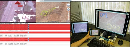
Remote System Monitoring Application (RSMA)
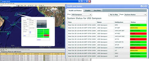
The Remote System Monitoring Application (RSMA) is a web-based server designed to automatically collect and present data from forward-deployed tactical assets. It provides decision-makers with clear, real-time insights into system operational status, enabling informed decision-making.
Built on a modern server-oriented architecture, RSMA ensures that all displays are dynamically updated without requiring manual browser refresh. It seamlessly integrates with multiple geographic visualization platforms, including Google Maps, MDP, AMP, and more, to enhance situational awareness.
VISION
VISION automatically associates relevant intelligence from a variety of sources to FMV to shorten the Find, Fix, Track, Target, Engage, Assess and Finish (F2T2EAF).
VISION is composed of several software components:
- FMV Layer - Graphic or information drawn over the video in a non-destructive manner.
- Media Fusion - Technique that synchronizes data from COP and FMV.
- Distributor - Software service that delivers FMV and layers to registered participants.
- Correlator - Rapidly associates multi-INT data with FMV via spatial-temporal algorithms.
- Alerts - Generate operator notifications in or near field of view.
Epsilon C5I has engineered VISION to deliver capabilities to multiple form factors:
- Command Center - large display formats that show FMV/Multi-int cross cueing.
- Analyst - Ozone widgets with various exploitation tools.
- Mobile - tablets and smart phones for field commanders.
- Sensor - for helmets, clothing, or attachment to platforms. MPEG-TS/KLV compatible Android/iOS applications assist blue force tracking and FMV/Meta-data sharing.
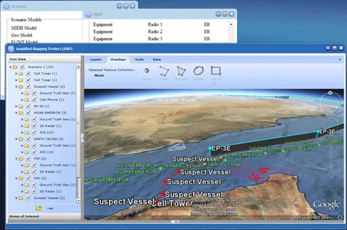
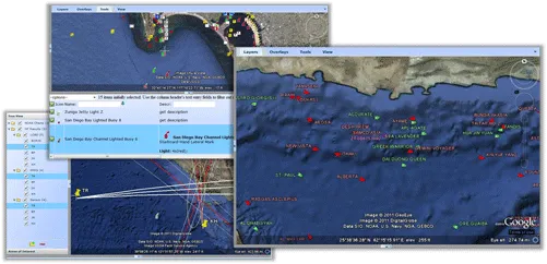
Amplified Mapping Product (AMP)
The Amplified Mapping Product (AMP) is a versatile mapping application built on the Google Earth plugin, designed to run in a web browser or within the Ozone Widget Framework (OWF). AMP enhances tactical decision-making with powerful visualization and interaction tools, including overlay drawing, range and bearing tools, and geospatial analysis features.
AMP offers an integrated, dynamic mapping solution to support a wide range of tactical and operational needs.
Key Features:
- Flexible Deployment – Operates as a standalone web application or seamlessly integrates with OWF.
- Advanced Geospatial Tools – Includes range and bearing calculations, geospatial drag-selection, and intuitive table sorting and filtering.
- Shared Mapping Framework – Provides a common map interface for client applications and remote data sources.
- Editable Data – Allows client applications to define editable data layers, enabling edits to points, lines, polygons, ellipses, and lat-lon boxes in 2D, 3D, and 4D formats, with changes returned to the client.
- Geospatial Query Support – Enables client applications to perform geospatial queries, with AMP returning actionable results.
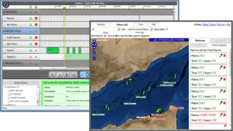
Fleet Adaptive Synthetic Trainer (FAST)
The Fleet Adaptive Synthetic Trainer (FAST) streamlines the development and modification of training scenarios, enabling faster and more efficient scenario creation. It leverages pluggable static and dynamic models, order of battle data, recorded intelligence data, and enhanced user interfaces to deliver adaptable and comprehensive training solutions.
FAST integrates seamlessly with virtually any relational database to display orders of battle, tracks, and SIGINT-related information. Supported databases include MIDB, AIS, TMS, GALE, and EPL, providing flexibility and compatibility with existing data sources.